10-728-How-A-Watershed-Works.jpg

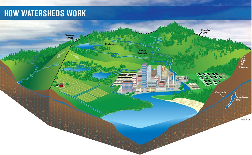
What is a watershed?

A watershed is an area of land that drains to a common point. When rain falls on an area of land, water that does not soak into the soil or evaporate into the air flows downhill. We often call this water “runoff” or stormwater. The outline of a watershed is defined by high points in the topography, like hills or mountains. Water flows downhill from higher places to a common low point, usually a body of water like a stream or lake. 


Often when we talk about a watershed, we focus on surface water, or the water we see on the landscape such as streams, ponds, rivers, lakes and wetlands. But a watershed also includes the groundwater under the surface of the land. In many watersheds, there is quite a bit of interaction between groundwater and surface water. Groundwater feeds streams and rivers during dry periods, and surface water recharges groundwater during wet periods. 

On the map of the Lake Thunderbird Watershed, the outline of the watershed is made up of high elevation points. Outside that watershed boundary, rain would flow to a different body of water or low point. Within that boundary, runoff flows toward Lake Thunderbird, often from yards to storm drains, from storm drains through pipes to creeks and from creeks to Lake Thunderbird. You can think of a bathtub as a very simplistic model of a watershed: the rim of the tub is the watershed boundary and the drain is the low point. Any water that falls within the tub’s rim will end up flowing toward the drain.


Runoff and Flooding in Norman

Runoff and Flooding in Norman

Stormwater Runoff

In urban areas, a much greater proportion of rain becomes runoff because a higher proportion of the landscape is covered with surfaces that keep water from soaking into the earth. We call these surfaces “impervious surfaces”. Examples of impervious surfaces include rooftops, driveways, roads and parking lots. When it rains, runoff picks up pollutants on the surface of the earth or on impervious surfaces, carries those pollutants to the nearest storm drain and from there to the nearest creek. Stormwater is carefully managed in urban areas to prevent flooding and protect local waterbodies from pollution. 


How we impact our watersheds

Discarded refuse contributes to pollution in our streams and eventually our water supply.

Discarded refuse contributes to pollution in our streams and eventually our water supply.

Almost anything we do to alter the natural landscape has the potential to impact the waterbodies within a watershed. For example, when we install pavement, we create an area of land that does not absorb water. The water that used to soak in, or infiltrate, now runs off and into the nearest ditch or storm drain. This runoff water may pick up pollutants on the surface of the ground, and the increased volume of runoff may erode stream banks and scour stream bottoms. Streams carrying these pollutants flow downhill to a receiving water, or the low point in the watershed. In our case, the receiving water is Lake Thunderbird. 

If streams flowing into the lake carry a lot of sediment, the lake will appear cloudy or turbid. The sediment will gradually settle out of the water and onto the bottom of the lake. In the short term, turbid water is more expensive for the water treatment plant to treat and can lead to waterbodies receiving nicknames like “Dirtybird”. In the long term, increased sedimentation decreases the amount of water the lake can hold. 

When water flows over the land surface, it picks up pollutants in its path and carries those pollutants to the nearest waterbody. In urban areas, common pollutants include pet waste, lawn clippings, lawn chemicals, fluids from automobiles, sediment and trash. In rural areas, common pollutants include sediment, waste from livestock, chemical fertilizers, insecticides and pesticides. 

Natural vegetation traps and filters many pollutants such as sediment, nutrients (nitrogen and phosphorus from natural or synthetic fertilizers) and some chemicals. Nutrients fertilize green plants in the lake just the way nutrients fertilize grass in your yard. Excess nutrients can cause excess algae. When we replace natural vegetation with vegetation like short turfgrass, we reduce the ability of the land to protect waterbodies from pollution. 


Land Use

Land use practices in the watershed and the health of surface waters are fundamentally connected. We can make land use and land management choices that improve the health of waterways. For example, areas of natural vegetation supported by healthy soils allow the most water to soak into the ground. In turn, this reduces the likelihood of local flooding and protects streams from large volumes of stormwater that can erode streambanks. Natural areas of vegetation also filter some pollutants from stormwater runoff before soils become saturated and water can no longer soak into the ground. 

The land areas that affect surface waters the most are the areas right next to streams, rivers, wetlands and lakes. These areas are called “riparian zones” or “buffer zones”. Leaving these zones intact may be the single most beneficial action we can take on behalf of surface waters. The roots of riparian vegetation stabilize banks and shorelines and prevent excessive erosion, which helps protect nearby properties and the stream itself. The vegetation also shades the water, which can drastically impact summer water temperatures in small streams. These zones also filter runoff and remove pollutants before they can enter the stream and provide a corridor for wildlife to move between protected areas.

Many of the alterations we make to the landscape are necessary and beneficial. How we plan development, however, can have a profound impact on the health of waterways. We can leave riparian areas intact, plan developments with buffer strips between imperious surfaces and streams and rivers, build up instead of out to reduce the amount of impervious surfaces present in our cities, and use best management practices to encourage water to soak into the ground rather than run off into nearby streams. Examples of practices that encourage water to soak into the ground include infiltration basins, rain gardens, native plantings and permeable pavement. We can also remove imperious surfaces that are no longer useful (such as abandoned buildings or parking lots) and replant these areas with native vegetation. By doing so, we increase the amount of water that can soak into the ground and provide a place for both urban wildlife and people to enjoy.

Pictured: Land use in a watershed.

Pictured: Land use in a watershed.

Graph of land use distribution.png